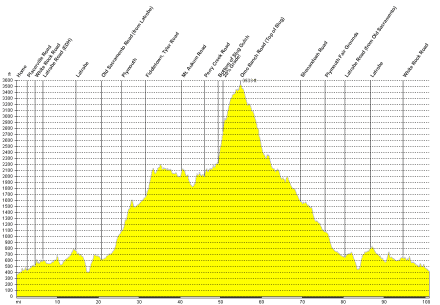
Route
| Miles to Turn | Total | Turn Point Description |
| 0.0 | Home | |
| 2.6 | 2.6 | Placerville Road (from East Bidwell) |
| 1.9 | 4.5 | White Rock |
| 2.0 | 6.5 | Latrobe Road |
| 8.1 | 14.5 | Straight through Latrobe |
| 5.9 | 20.5 | Left turn at the stop sign on "Old Sacramento Road" to Plymouth |
| 5.3 | 25.7 | Through Plymouth |
| 0.6 | 26.3 | Right (Actually Straight) Fiddletown Road |
| 5.1 | 31.4 | Fiddletown |
| 0.2 | 31.6 | Up Tyler Road |
| 5.3 | 36.9 | Bridgeport School Road |
| 2.2 | 39.1 | Cedar Creek Road |
| 1.3 | 40.4 | CR-E16 Mt Aukum Road |
| 5.2 | 45.6 | Fairplay road |
| 0.3 | 45.9 | Perry Creek Road |
| 3.5 | 49.4 | Slug Gluch Road |
| 5.4 | 54.8 | Right down Omo Ranch Road |
| 5.3 | 60.1 | Straight Omo Ranch Road |
| 3.6 | 63.7 | Left CR-E16 (Mt Aukum Road) |
| 5.8 | 69.5 | Left Shenandoah Road |
| 3.9 | 73.4 | Left CR-E16 (Shenandoah Road) |
| 1.7 | 75.1 | Straight Main Street |
| 0.4 | 75.5 | Plymouth Fair Grounds |
| 4.9 | 80.4 | Right Latrobe Road |
| 6.2 | 86.6 | Straight through Latrobe |
| 8.0 | 94.6 | Left White Rock Road |
| 2.0 | 96.6 | Right Placerville Road (from White Rock) |
| 4.5 | 101.1 | Home |
Trip Data from my house
101.1 miles
6300 ft climbed
15.2 MPH average
© Roland Wooster, 2007. All rights reserved.